A recent medium-rise development along Karamu Road encountered groundwater at barely two metres depth, well above what desktop models had predicted. The contractor was facing a twelve-metre cut in saturated gravels with adjacent heritage buildings showing pre-existing settlement cracks. That project stayed on schedule because the monitoring array, inclinometers, piezometers, and optical survey prisms, was commissioned before the first excavator bucket broke ground. In Hastings, where the unconfined aquifer of the Heretaunga Plains sits just below the surface, excavation monitoring is not a compliance afterthought; it is the control system that keeps the cut stable, the neighbours calm, and the budget predictable. A solid CPT test campaign ahead of bulk earthworks provides the baseline pore pressure profile that every subsequent monitoring reading is measured against, ensuring that deviations are caught when they are still centimetres, not emergencies.
In the Heretaunga Plains, effective monitoring starts with knowing the aquifer, not just the excavation geometry.
Technical details of the service in Hastings
Risks and considerations in Hastings
Hastings expanded rapidly after the 1931 earthquake, which reshaped both the built environment and the regulatory approach to ground risk. Much of the central commercial stock sits on shallow pad footings from the post-quake rebuild era, structures that tolerate very little differential movement. When a modern excavation advances within the zone of influence of these older buildings, the margin for error shrinks to single-digit millimetres. Delaying or minimising a monitoring programme in this context transfers the cost risk onto the principal: a single crack claim, a stop-work order from Council, or a loss-of-support dispute can erase the entire project contingency. The Hawke's Bay Regional Council also maintains strict groundwater management protocols, and a piezometer record that demonstrates compliance is the first line of defence if a neighbouring bore runs dry. Monitoring, in short, is the evidence trail that protects both the works and the professional indemnity of the design team.
Our services
Our Hastings-based monitoring packages are scoped to the excavation risk category, from simple batter cuts to fully anchored soldier pile walls. Every deployment includes baseline readings prior to disturbance, a detailed instrumentation plan signed by a CPEng geotechnical engineer, and a cloud-accessible dashboard for the contractor and design team.
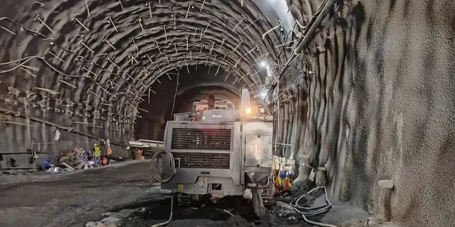
Deep Excavation Surveillance
Continuous inclinometer arrays behind soldier pile walls, combined with load cells on tie-back anchors and optical prisms on capping beams. Designed for cuts exceeding 6 m where NZS 3404 Category 3 monitoring applies.
Groundwater & Pore Pressure Monitoring
Standpipe and vibrating wire piezometers installed in nested clusters to track the Heretaunga aquifer response during dewatering. Data used to calibrate the groundwater model weekly and adjust pumping rates.
Adjacent Asset Protection
Pre-construction condition surveys, crack gauges, and tilt meters on neighbouring buildings and utilities. Trigger levels are agreed with Council and asset owners before excavation starts, reducing dispute risk.
Real-Time Alert Dashboards
Secure web portal with automated SMS and email alerts tied to amber and red thresholds. All data is time-stamped, georeferenced, and exportable for monthly engineer reports and Council audits.
Questions and answers
What does a typical geotechnical excavation monitoring setup cost for a project in Hastings?
For a standard commercial excavation in the Hastings CBD, monitoring programmes typically range from NZ$1,450 for a short-term batter cut with survey prisms and piezometers, up to NZ$3,610 for a fully instrumented anchored wall with inclinometers, load cells, and automated total station coverage over several months. The final scope depends on cut depth, proximity to sensitive structures, and the number of instruments required by the site-specific TARP.
How often are inclinometer and piezometer readings taken during active excavation?
During active cut phases, particularly within the first three metres of exposure, we log inclinometers and vibrating wire piezometers at hourly intervals. Once the excavation reaches design depth and support elements like shotcrete or anchors are curing, the frequency shifts to daily readings. After backfilling, we maintain a weekly schedule for at least three months to confirm that ground movements have stabilised.
Which Hawke's Bay Regional Council rules apply to excavation dewatering monitoring?
The Regional Resource Management Plan sets minimum monitoring requirements for any dewatering exceeding 20 cubic metres per day. Our programme includes nested piezometers to separate shallow and deep aquifer responses, and we submit weekly water level reports to the Council's compliance team. Trigger levels are set against pre-construction baseline readings taken over a minimum ten-day period.
What is a TARP and why is it mandatory for monitored excavations?
A Trigger Action Response Plan (TARP) is a document that pre-defines movement, vibration, or pore pressure thresholds and the specific actions required when those thresholds are reached. Under NZS 4203 and NZGS guidelines, every monitored excavation must have a signed TARP before work begins. It removes ambiguity: an amber exceedance triggers a design review within 24 hours; a red exceedance halts work and mandates immediate shoring inspection.
Can you install monitoring instruments before the main contractor mobilises?
Yes, and we recommend it. Baseline inclinometer and piezometer readings must be established before any bulk excavation disturbs the ground. Our team typically mobilises two to three weeks ahead of the earthworks contractor to install instruments, run the initial survey, and confirm that all data is streaming correctly to the dashboard. This early phase also allows us to identify and replace any faulty sensors without impacting the construction programme.