The alluvial gravels under Havelock North behave very differently from the fine silts and clays deposited closer to the Clive River mouth. One site might drain freely within hours of a downpour, while another just five kilometres away holds moisture for weeks, creating a completely different set of risks for settlement or buried infrastructure. Mapping those contrasts without turning a hectare of productive orchard into a grid of test pits is where electrical resistivity and Vertical Electrical Sounding (VES) earn their place in the pre-construction budget. We run Schlumberger and Wenner arrays across sections from Flaxmere to Haumoana, tying the measured resistivity profiles directly to NZGS borehole logs so the picture you get isn't just a colour contour — it's depth-calibrated stratigraphy ready for the council consent package.
Resistivity data calibrated with a single CPT sounding gives you more actionable stratigraphy than five boreholes drilled blind across heterogeneous alluvium.
Technical details of the service in Hastings
Risks and considerations in Hastings
The Heretaunga Plains sit on a deep, unconfined-to-semiconfined aquifer system that supplies over 80% of Hastings' water. A misinterpreted resistivity profile — for example, confusing the regional piezometric surface with a perched lens — can put a contractor's dewatering plan 20 m off target and trigger consent non-compliance under Hawke's Bay Regional Council rules. The coastal margin from Haumoana to Te Awanga adds a second hazard: seasonal seawater intrusion pushes pore fluid conductivity above 5000 µS/cm, which flattens the resistivity contrast and hides thin clay aquitards unless the inversion parameters are tuned specifically for low-resistivity environments. We run reciprocal measurements and repeatability checks at every VES station because a single noisy data point can shift a modelled layer boundary by several metres in the 1D inversion.
Our services
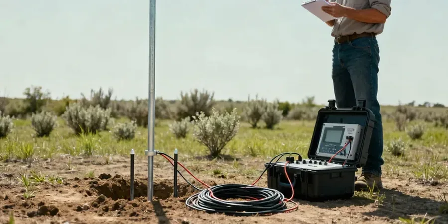
Our resistivity group in Hastings provides three tiers of electrical survey, from quick profiling for service trench alignment through to deep VES soundings tied into the regional groundwater model.
1D Vertical Electrical Sounding (VES)
Point-depth resistivity curves expanded from 1.5 m to 100 m AB/2 spacing. Ideal for mapping gravel thickness above the aquitard beneath Hastings CBD or Havelock North subdivisions, with each station calibrated against existing borehole or CPT data.
2D Electrical Resistivity Tomography
Continuous resistivity cross-sections up to 400 m per spread. Used across the plains to trace paleochannel boundaries, locate buried services under redevelopment sites, and delineate the freshwater-saltwater interface near Te Awanga.
Resistivity for Groundwater & Contaminant Mapping
Time-lapse and baseline resistivity grids designed for Hawke's Bay Regional Council compliance. We map leachate plumes, monitor aquifer recharge zones, and define cut-off depths for retention pond liners on the silty loams common across the district.
Questions and answers
How much does a VES resistivity survey cost for a typical Hastings section?
A single VES station with four to five expanding spacings and a calibrated depth model generally runs between NZ$1,040 and NZ$1,850, depending on cable deployment length and access conditions. Larger 2D tomography lines or multi-station grids on orchard blocks scale upward based on line metres and electrode count. Every quote includes data processing, inversion modelling, and a short report with the interpreted geoelectric layers.
How deep can you see with resistivity on the Heretaunga Plains?
With a 200-metre cable spread in Schlumberger configuration, we routinely reach 75 to 100 metres below ground level. That covers the full thickness of the unconfined gravel aquifer and the upper portion of the confining aquitard. Depth of investigation is always limited by the site's electrical noise — nearby power lines, buried steel pipes, or reinforced concrete foundations — so we run a noise test before the full spread is laid out.
Do I still need boreholes if I commission a resistivity survey first?
Resistivity gives you continuous lateral coverage that boreholes alone cannot provide, but it does not replace a physical sample for classification or strength. Most Hastings projects combine two or three well-placed CPT soundings or boreholes with a resistivity line. The borehole data calibrates the resistivity model; the resistivity model fills in the gaps between boreholes, so you avoid drilling through a buried channel that nobody predicted.